Not All Who Wander Are Lost

Not All Who Wander Are Lost
June, 2019 - Mount Denali, Alaska

Sunday, October 17, 2010

Colorado National Monument

We took a drive today back into Colorado to visit yet another beautiful national monument.

The Colorado National Monument is 32 square miles of canyons.  Let me show you some pictures.

Colorado Nat'l Monument Wedding Canyon 2

Wedding Canyon


Colorado Nat'l Monument Window Rock

Window Rock


Colorado Nat'l Monument

Monument Canyon


The spire in the picture above is called Independence Monument.  It is a favorite for rock climbers.  These guys must have been at it for some time.  There’s one guy almost to the top and another on the ledge on the right.

Colorado Nat'l Monument Independance Monument Rock Climbers

Colorado Nat'l Monument Ute Canyon 2

Ute Canyon


While we were at Rocky Mountain National Park, we saw a stream that was near the headwaters of the Colorado River.  That streams sure has grown.

Colorado Nat'l Monument Colorado River

Colorado Nat'l Monument Dead Tree ViewAnd, finally here’s another dead tree picture.  For some reason, they appeal to me.


We discovered that the Moab area is a huge off-road area.  I’ve never seen so many Jeeps and ATVs.  I’ve also never seen so many creative ways to transport them.  A lot of people have toyhaulers.  We’ve seen trailers of all sizes, Jeeps in the bed of trucks, motorhomes towing Jeeps, motorhomes towing trailers with Jeeps on them.  But the scariest I saw was a large pick-up pulling a very long fifth wheel, pulling a trailer with ATVs on it.

Don’t wish upon a star – Reach for one!

Saturday, October 16, 2010

Arches National Park

We arrived at OK RV Park in Moab, Utah yesterday afternoon after another incredibly scenic drive.  This is another Passport America park and we’re paying $15.50 per night.  I really like this park.  Rather than a gravel parking lot, which is what many campgrounds out here are, there are trees and even some grass!  We have a full hook-up, 50 amp, pull-through, level site with a fantastic view out the back window and free wi-fi and cable. 

Utah OK RV Park site Utah OK RV Park View out Back Window

This is the view out of our back window.

We spent the day today at Arches National Park, and were amazed by the beauty of the sculpted rock scenery.  We drove through the park and stopped to see the highlights.  Some were near the road, and others required some hiking.  According to the map, we hiked about 8 miles total, but it was worth every step.  See for yourself!  Most of the pictures have people in them so you see how massive these arches, spires, pinnacles and balanced rocks are.

Arches NP Balanced Rock

This is called Balance Rock.


Arches NP Double ArchDouble Arch


Arches NP The Windows                                        The Windows

Arches NP Landscape Arch

This one is called Landscape Arch.  It’s span is 290 feet and is the longest arch in the world.  In 1991 a rock slab 60 feet long and 11 feet wide and four feet thick feel from the underside of the arch. 

Arches NP Dead Tree 1

This dead tree was in the shade, and I like the contrast of the tree and rock.


Arches NP Park Avenue

                        This is called Park Avenue

Arches NP 3

                               These are called fins.

We’re headed back to Arches on Tuesday to participate in a three hour ranger led hike in the fiery furnace area.  Stay tuned for more pictures :)

As we were driving home, I was thinking about how very lucky I feel.  I’m so glad we made the choice to take the risk of thinking outside the box and bucking societal convention.  There is not a luxury car, big house or expensive “stuff” that can hold a candle to the incredible sites we have seen in the last few weeks.  This experience is truly priceless!

Don’t wish upon a star – Reach for one!

Friday, October 15, 2010

Mesa Verde National Park

On Wednesday we visited yet another fabulous National Park.  At Mesa Verde archeologists have found more than 4,800 archaeological sites including 600 cliff dwellings in the cliff alcoves above Montezuma Valley.  These dwellings, many of them being multi-storied, date back to 500 to 1300 A.D. and are remarkably preserved.

The most famous site is called Cliff Palace.  It is the largest cliff dwelling in North America, has over 150 rooms, and is estimated to have been home to about 100 people.  The only way to tour the site is by signing up for a ranger-led tour.  It was $3 a person, and well worth the cost.  The tour was very informative, and the dwelling was amazing.  Some sections are four stories high.  The cave section goes back 90 feet, and there are rooms all the way to the back.  It is believed many of these rooms were used for food storage.

Mesa Verde Cliff Palace 4

Mesa Verde Cliff Palace 3

Mesa Verde Balcony House 32 ft. LadderWe also toured Balcony House which was another dwelling accessible only by signing up for a ranger-led tour.  To get to this one, we had to climb a 32 ft. ladder.  To get out, we had to crawl through two rock tunnels on our  hands and knees and then climb more ladders.  I’m really glad we’re young enough to do these more strenuous types of tours.

Mesa Verde Balcony House Kiva

Spruce Tree House is a dwelling accessible to all park visitors.  We walked down 1/2 mile into the canyon to see this one.

Mesa Verde Spruce Tree House

From there we hiked another 2.4 miles to see some petroglyphs.  This was my idea.  I didn’t realize we’d be hiking along the side of the cliff face.  It was quite strenuous, but the payoff was pretty cool.

Mesa Verde Petroglyphs 4 

And in case you want to see more, this cliff dwelling is called Square Tower House.

Mesa Verde Square Tower House

Right now we’re headed from Colorado to Moab, Utah to see Arches National Park and a few other sites.  What a beautiful drive!  The weather is still fantastic.  Highs today are expected to be in the 80s!

Thanks to those of you that commented on our air card problems.  We did finally get it resolved with them, and we again have internet service although this air card keeps going dormant causing us to have to frequently hit the refresh button.  We didn’t have that with the first air card.  Doesn’t it always seem to be something :)

Don’t wish upon a star – Reach for one!

Tuesday, October 12, 2010

Four Corners Monument

On Monday we went to the Four Corners Monument which is the only place in the country where four states meet in one spot.  There are other places where you can see four states from a mountaintop, but this is the only place they actually meet.
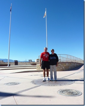
Colorado 4 Corners Monument 2We were under the impression that it was part of the National Park system, but it wasn’t.  It’s actually on Navajo land.  They charge $5 per person, but it was worth it to say we were there. 


Colorado 4 Corners Monument 4

Colorado 4 Corners Monument 5

The actual monument area is nicely done.  I heard they had redone it just this summer, and there were still bulldozers working on the outer area.  All around the monument are stalls with Native Americans selling stuff.  Most of it was the typical stuff you see everywhere, but there was one guy who had some beautiful jewelry with stones he polished himself and made into pendants.  I was tempted, but I wasn’t willing to pay what he was charging :)

From there we headed to Aztec Ruins National Monument in Aztec, New Mexico.  These ruins are actually from the Pueblo people who lived here in the 1100s, centuries before the Aztec empire prospered.  Anglo settlers mistakenly named the place Aztec based on stories they heard about Cortez’s conquest of Mexico.

New Mexico Aztec National Monument 1

New Mexico Aztec National Monument 2

When these ruins were excavated, it was discovered the largest of the houses had at least 500 rooms and rose to three stories.  There were a number of kivas found, which were round rooms believed to be used for ceremonies and as gathering places. 

The Great Kiva was rebuilt in 1934 and a roof was added to show the public what it must have looked like hundreds of years ago.  I’m always so amazed at the skill these ancient people had!

New Mexico Aztec National Monument Great Kiva

New Mexico Aztec National Monument YuccoThis is the largest yucca plant I have ever seen.  The Ancestral Pueblo people used the yucca fibers to make all kinds of things including baskets, sandals, rope, mats and blankets.  These people were amazingly innovative and creative.


Today we stayed home and took it easy.  We took care of some business and ran a few errands.  Cortez itself is not much of a tourist town.  We did find a micro brewery/restaurant called Main Street Brewery.  I’m not a beer drinker, but Kevin said the beer was good.  I had a chicken sandwich which was very tasty.  I loved their seasoned fries.

We’ve been really frustrated with our internet over the last 10 days.  In June we got a Verizon air card through the 3G store which was recommended by other fulltimers.  After 4 months, they informed us that our account was being sold to another company.  Since we’ve been with the new company, our air card won’t work.  They sent us a new one at our current location, and we have the same problem as the old one.  The people there don’t seem to know what they’re doing.  I liked this plan because there was no contract and it was $10 a month cheaper than through Verizon.  At this point, I’m ready to give up on them and get the air card directly from Verizon even if it means a 2 year contract and the $60 a month.  I called the 3G store and they told me they are distancing themselves from this new company.  How nice for them.  That doesn’t help us any, does it!

We’ve been using my cell phone tethered to the laptop.  Our cell phone provider is US Cellular, and they don’t have the coverage area that Verizon has.  It’s been working, but very slow.  We still have a year and a half on our cell phone contract. 

I know some people are using their new Droid phones for their internet.  We’ve been able to use Kevin’s computer with Windows 7 as a hot spot so we can both be on at the same time.  I don’t know how the new phones work.  I wish someone would just tell me exactly what would work best for us.  All this technology stuff can drive you out of your mind!!!

Don’t wish upon a star – Reach for one!

Monday, October 11, 2010

San Juan Skyway

Sunday we drove the 250 mile San Juan Skyway loop.  This drive is designated a scenic byway, and we definitely were not disappointed!  It was another Sunday spent in God’s natural cathedrals.

We began by driving along the west side of the loop.  This takes you through a valley of the San Juan Mountains along the Delores River.  The sides of the mountains were covered with glowing aspens, at the base was a strip of land used for ranching, and then the river ran along the road.  On the other side were more mountains.  There are no words to describe the incredible beauty of this area.  My pictures don’t come close to showing you, but I’ll show you a few anyway. 

Colorado San Juan Skyway Aspen 3

Colorado San Juan Skyway Aspen 2

Eventually the road led to the mountaintops.  We found this lake nestled among the mountains.  It’s called Trout Lake.

Colorado San Juan Skyway Trout Lake

After some white knuckle stretches in the mountaintops, we arrived in Telluride.  What a great little town even if you don’t ski. 

They have a gondola system which is the first and only free public transportation of its kind in the US.  All the electricity to power it comes from wind.   You can ride to Mountain Village and to the various ski runs at the top.  There is also an extensive mountain biking trail system up there.  Riders can bring their bikes on the gondola and must sign a waiver at the top.  This is for serious bikers only!

Colorado Telluride Gondola with Bike

These next pictures are of some of the ski runs minus the snow.  I was scared just standing at the top and looking down.  I can’t imagine actually skiing down these.  I’ve never downhill skied, but still!  Both of our boys ski, so these pictures are for them to dream about :)  The town at the bottom is Telluride.

Colorado Telluride Ski Run 1

Colorado Telluride Mountain Ski Trails

Colorado Telluride Ski Map

There is a small community up there called Mountain Village.  They even have their own little airport.  You can see the runway on the right in this picture.

Colorado Mountain Village above Telluride with Airstrip 

Colorado Telluride Dusky Grouse BirdThis Dusky Grouse sitting in the tall grass on the edge of one of the ski paths.


After leaving Telluride, we began driving on the east side of the loop; more white knuckle mountain roads, but oh the views!

Colorado San Juan Skyway Mountains

Colorado San Juan Skyway Mountains 3

Colorado San Juan Skyway Box Canyon Falls

We stopped in a little town called Ouray to hike to the Box Canyon Falls.  This waterfall rushes down through rock canyon walls.  The water is naturally heated underground, and the town uses if for a hot springs pool complex.


On the outskirts of Silverton, Colorado are the Red Mountains.  The red colors are beautiful, but are not natural.  In the late 1800s, silver mines dominated these mountains.  Millions of dollars in silver were pulled from the mines.  However, water seeping through the waste rock left behind, has caused the red coloring.  There is actually a movement to restore the mountains to their natural state.  If you look closely, you can see some of the mine buildings and railroad tracks left behind.

Colorado San Juan Skyway Red Mountains with Mines

 Colorado San Juan Skyway Red Mountains

I took many more pictures, but these will give you an idea of the magnificent, amazing, phenomenal, beautiful, breathtaking images we saw.  I highly recommend this area to everyone especially in the fall.

Don’t wish upon a star – Reach for one!

Saturday, October 9, 2010

Canyons of the Ancients National Monument

On Saturday we started our day at the Anasazi Heritage Center.  It is the gateway to Canyons of the Ancients National Monument.  The center is an excellent museum with many interesting displays about Ancestral Puebloen life on the Great Sage Plain.  We walked along the 1/2 mile path to see a view of the McPhee Reservoir.

Cortez, Colorado McPhee Reservoir

This bush called a Gambel Oak was growing all along the trail.  I never realized oak could grow as a bush.  I’ve only ever seen oak as very large trees.  The leaves had the same shape as those of an oak tree only smaller.

Anasazi Heritage Center Gambel Oak

This mountain is called Sleeping Ute Mountain.  Legend has it the mountain is a sleeping warrior god and some day he’ll wake up and help the Ute people again.  His head is on the right, the large hump are his folded arms, further down are his knee and then his foot.  The next picture is the same mountain from the other side.  Now his head is on the left.  For some reason, I’m fascinated with natural wonders that are supposed to be in the shape of something else.  I look for shapes in clouds, too :)

Cortez, Colorado Sleeping Ute Mountain 1

Cortez, Colorado Sleeping Ute Mountain 2

Canyon of the Ancients National Monument was established in 2000 and covers 166,000 acres.  More than 6,000 archaeological sites have been recorded.  This area has the highest known archaeological site density in the nation.  We drove through a good portion of it.  I’ve never seen so much sage and juniper. 

We visited Lowry Pueblo which is the only developed site within the monument.  It has been excavated to give visitors a chance to see the 40 rooms at this site.  A roof has been added to help preserve the site.  Otherwise, it looks much as it did when it was excavated.

Canyons of the Ancients Lowry Pueblo

Visitors are allowed to go inside through small doorways.  These people were small.  Average height for men was 5’3” and for women 5’1”. 

Canyons of the Ancients Lowry Pueblo Small Kiva

This is a kiva inside the structure.  A kiva was a large room used for ceremonies and group events.


Canyons of the Ancients Lowry Pueblo Large Kiva

There was also a large kiva.  The stones on the floor represent a winter and summer figure.


Our last stop was the Hovenweep National Monument.  This is a canyon with a number of towers built by the Pueblo people about 700 years ago.  The masonry skills of these people is amazing.  There are a number of different sized towers along this canyon suggesting there was an entire community living here. 

Hovenweep National Monument 1

Hovenweep National Monument 2

It was another beautiful day with temperatures in the upper 60s. 

Don’t wish upon a star – Reach for one!